Maps. I think one issue which sets an explorer and traveler apart from the rest of the world, is his or hers interest in maps. I can honestly spend many hours looking into every little symbol or detail on a map, mainly to register it in my head, if, when exploring, I get lost and have to backtrack. And when I got approached by George if he could do an interactive map on one of my Expeditions, I was genuinely happy! Said and done, he did a great job! But, one of the questions I had was; “What makes you want to do interactive maps?” Here´s his answer!
The why and how I made interactive Google Maps of Historic Events
by
George Stiller
I began making interactive maps of historic events because I kept going to Google Map to find the locations in the various books I had been reading. It struck me that it would enhance my reading if I created my own Google Map of the book. Thus, I was able to zoom in on and track the locations and people while I was reading about in both fiction and non-fiction books. Having developed several of these maps, I decided that I should share them with others who might find them interesting and try to teach others to map their reading. So I created my blog MyReadingMapped.
After a period of time, I noticed that the maps that got the most attention were those of historic events. So, I modified my blog to contain only maps on historic events. Then it dawned on me, that without a college degree, I have no credibility and that I am not a recognized authority on history. To solve that problem, I decided to find 100+-year old eFree Google Books, or online journals, written by the explorers themselves and even Wikipedia pages on the exploration that my map locations could be linked to on a by page basis for credibility. Thus, the map becomes a library portal to all the knowledge on the Internet.
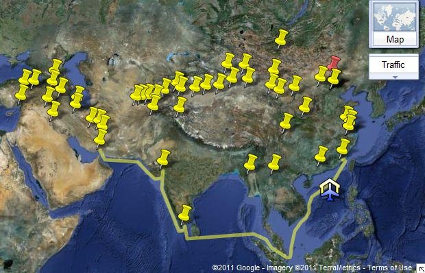
My first map of this type was the Interactive Civil War Map. I knew there would be great interest in the subject and I found the links and coordinates I needed on Wikipedia’s List of Civil War Battles, which was very confusing to use and required the visitor to use a complicated and time consuming process to get to a Google Map for each and every battle one-by -one. On the other hand, my map was designed to be easy to use, enabled you to zoom in on the battle and made all the battles visible at once so you can see how they relate to each other without the complicated process. These maps enable you to zoom in on the actual locations, see the buildings, the forts, the ancient ruins, etc. and read the actual words of the explorer, see the terrain as they saw it 100+ years ago in terrain mode, and what it looks like today in satellite mode. These maps can even provide directions, hotels and other points of interest. Some maps include links to National Archive photos, Wikipedia pages, and animations from CivilWarAnimated or AmericanRevolutionAnimated.
After placing a few referrals on various online forums, interactive maps of historic events began to take off. My hope is that teachers would use it to inspire reading and writing to students who are currently fixated on an online media, and that travelers and followers of explorers would use these maps to plan their next vacation.
My most popular maps are the following:
- Interactive Civil War Map
- Sunken Ships of the Atlantic
- Explorations of Charles Darwin, Marco Polo, Mungo Park and Henry Morton Stanley
- The American Revolution
- Environmental Disasters
Until recently, all my maps were about explorers who had died a long time ago. The map on Mikael Strandberg’s 2004 Siberian Expedition was my first living explorer who was kind enough to allow me to do so and provided the materials I needed. I now have twenty-nine Google Maps on historic events and two Google Map games called “Day of Atonement” and “Prag’s Google Street Road Rally.” It is of interest to note, the research involved and the creation of these maps has uncovered some errors in commonly held facts on history. I have found what I believe are errors in traditional exploration maps on Wikipedia in regard to Marco Polo and Cortès, and located odd details mentioned in books that affected history and you can read about them on my blog.
So today, start experiencing history digitally by making your own maps of an historic events and uncover your own discovery of little known facts that only a Google Map can reveal.

George Stiller is a retired marketing communications manager who began his 35 year career in advertising and marketing as paste up artist. As an ad agency art director, George has helped to establish Agfa-Gevaert as a worldwide leader in diagnostic medical imaging systems. As a corporate graphic design manager, George’s workflow improvements helped United States Surgical Corporation to become one of the fastest growing companies worldwide. As a marketing communications manager for MechoShade Systems, George helped to establish the MechoShade brand as the third most recognized brand in the commercial shade industry and helped to develop the ImageShades you have seen at Levis and the Gap. Now that George is retired, he developed his blog, MyReadingMapped, and its 30+ interactive Google Maps on history.
Visit him on Facebook!
Hello,
My name is Andrew, I was interested in how you get started with a career in exploring. I have always been interested in it, and from what little exploring i have done, i love it. Anything would help and be greatly appreciated.
Thank you,
Andrew
Hi Andrew,
There´s no rules as such, you need an idea and go for it!
However, there is a lot of reading if you check the guest writer section on my home page, see http://www.mikaelstrandberg.com/guest-writers/, where you have a lot to read and just check through the site, one for example check this section and look through the older entries section http://www.mikaelstrandberg.com/?s=explorer
Good luck!
M
Excellent post! Maps….. They are an essential part of planning for any successful expedition. There is no such thing as too much research of the regions and specific areas to which we choose to travel. Investigation of all aspects is prudent, and being aware of the territories past history is certainly an asset because it offers us perspective and knowledge that could prove critical when we finally embark on our journey. Any and all risks should be calculated. The better prepared we are, the higher the chances of a favourable outcome and a positive experience and newly gleaned knowledge.
Dear Mikael,
to be part of an expeditions is one of my dreams.
I have tried to find someone / convince one of my friends to actually plan and go for a trip together, but unfortunately non of them wants to join.
Therefore, I’m trying to find an organisation who is planning such trips.
All I could find are adventure holidays, but not an expedition or a long trip (e.g. from Germany/UK to Mongolia).
Do you know an organisation I could contact or which is organising such trips?
Your help is much appreciated.
Kind regards
Nana